


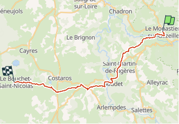
J1 Stevenson : Le Monastier - Le bouchet

ARPF
User

Length
27 km

Max alt
1227 m

Uphill gradient
838 m
Km-Effort
37 km

Min alt
763 m

Downhill gradient
545 m
Boucle
No
Creation date :
2015-05-28 00:00:00.0
Updated on :
2015-05-28 00:00:00.0
7h51
Difficulty : Difficult

FREE GPS app for hiking
 SityTrail
IGN / Geographical institutes
SityTrail Plus
The world is yours!
About
Trail Walking of 27 km to be discovered at Auvergne-Rhône-Alpes, Haute-Loire, Le Monastier-sur-Gazeille. This trail is proposed by ARPF.
Description
IE: 98 P2 T2
Positioning
Country:
France
Region :
Auvergne-Rhône-Alpes
Department/Province :
Haute-Loire
Municipality :
Le Monastier-sur-Gazeille
Location:
Unknown
Start:(Dec)
Start:(UTM)
578420 ; 4976769 (31T) N.
Comments